The only well in the Withlacoochee, Little, or Alapaha River watersheds that seems to be instrumented for near-realtime depth measurements is in Valdosta. That well is now at historic lows, compared to 55 years of back data.
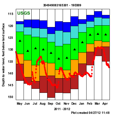 On the
graph to the right, the black triangle in the middle of the green is the median over those 55 years since 1957. The green is 25th to 75th percentile. The yellow is 10th to 24th percentile. The red is below 10th percentile. I’m guessing below the red means never been seen that low before in that month.
On the
graph to the right, the black triangle in the middle of the green is the median over those 55 years since 1957. The green is 25th to 75th percentile. The yellow is 10th to 24th percentile. The red is below 10th percentile. I’m guessing below the red means never been seen that low before in that month.
The current depth shown, 137.52 feet below the surface on 26 April 2012, is not the lowest ever seen, which was 152.31 feet on 19 September 1990. But apparently it is lower than seen before for April.
Maybe we should think about water conservation more frequently than just when Valdosta’s water pumps have problems. Not just for watering lawns; also for agriculture and silviculture. Maybe we should try to plant crops that don’t require as much irrigation, or plant them in ways that don’t lead to so much evaporation. Maybe we should be more careful about clearcutting trees, which causes rapid runoff that doesn’t get back into the groundwater as much. Maybe we should think about how much growth do we want.
-jsq