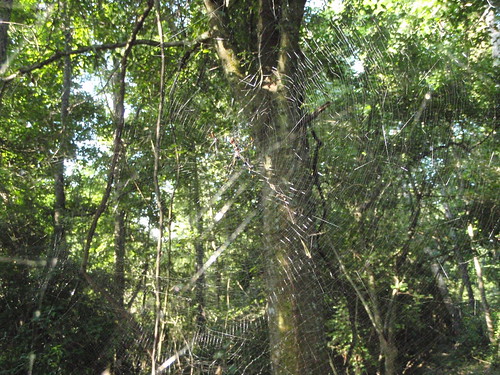
Spider Webs
Spider webs, Lowndes County, Georgia, 21 June 2009, picture by Gretchen Quarterman.
 Portugal admitted locking everybody up wasn’t working,
and shifted to treatment and prevention:
Portugal admitted locking everybody up wasn’t working,
and shifted to treatment and prevention:
Five years later, the number of deaths from street drug overdoses dropped from around 400 to 290 annually, and the number of new HIV cases caused by using dirty needles to inject heroin, cocaine and other illegal substances plummeted from nearly 1,400 in 2000 to about 400 in 2006, according to a report released recently by the Cato Institute, a Washington, D.C, libertarian think tank.Of course, if we did that in the U.S., we’d probably have to close quite a few prisons.“Now instead of being put into prison, addicts are going to treatment centers and they’re learning how to control their drug usage or getting off drugs entirely,” report author Glenn Greenwald, a former New York State constitutional litigator, said during a press briefing at Cato last week.
Under the Portuguese plan, penalties for people caught dealing and trafficking drugs are unchanged; dealers are still jailed and subjected to fines depending on the crime. But people caught using or possessing small amounts—defined as the amount needed for 10 days of personal use—are brought before what’s known as a “Dissuasion Commission,” an administrative body created by the 2001 law.


It looks to me like a common buckeye, Junonia coenia. Amusingly, there’s no record of it in Lowndes County.
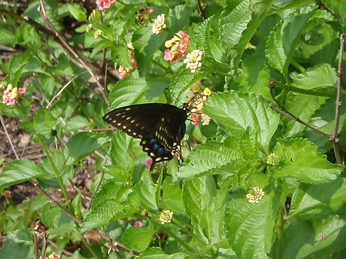
I’m thinking this one is a Black Swallowtail, Papilio polyxenes. Also no record of it in Lowndes County.
Any butterfly experts out there?
 David Roberts posts on grist.org about
Why we overestimate the costs of climate change legislation,
12:09 AM on 29 Jun 2009:
David Roberts posts on grist.org about
Why we overestimate the costs of climate change legislation,
12:09 AM on 29 Jun 2009:
As for modeling innovation, that’s always been the Achilles heel of economic forecasting. In this piece, Eban Goodstein and Hart Hodges trace a history of cost overestimations around environmental regulation. Again and again, models have underestimated the pace of business and technological innovation.Vinod Khosla was one of the founders of Sun Microsystems, the company that mainstreamed computer workstations, has long been a venture capitalist, and has been investing successfully in renewable energy for years.Today’s modelers surely do all they can to incorporate innovation. (As Brad notes, the CBO tries.) But there are constraints to how precisely this can be done. In 1980, McKinsey reported to AT&T that mobile subscriptions would rise to 0.9 million by 2000. The real number turned out to be … 109 million. (This factoid is among many interesting tidbits in this presentation from Vinod Khosla.)
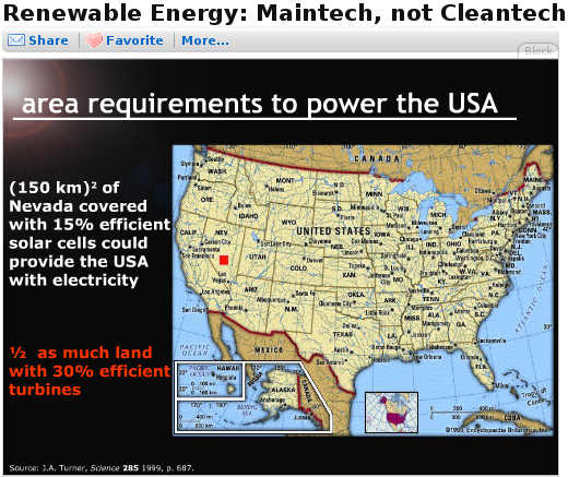
The little red square in the Nevada desert is all the area it would take to power the U.S. with solar panels. And that’s before further efficiency improvements. No reason it all has to be in Nevada, of course: Georgia has a lot of sun. Distributed is better than centralized.

 In Salon, Chris Kahn writes that
Winners and losers emerge in climate bill:
In Salon, Chris Kahn writes that
Winners and losers emerge in climate bill:
Owners of large tracts of forest land also will get a lot of interest from the business community. Like farmers, environmental experts see them as a huge player in the carbon economy because of their natural ability to absorb carbon.The picture is of Garcia River Forest, “recognized by the California Climate Action Registry as a certified source of carbon credits.”Louis Blumberg, director of climate change for the Nature Conservancy’s California chapter, envisions a system in which forest owners could make money simply by signing an agreement to cut down fewer trees for lumber.
The Nature Conservancy did just that last year with the Conservation Fund, a nonprofit agency that owns about 24,000 acres of redwood and douglas fir forest northwest of San Francisco. The groups changed the logging schedule on the property, and the fund expects to receive about $2 million from Pacific Gas and Electric, which participates in a regional climate initiative similar to the one that the Waxman-Markey bill would create around the country.
“This is really a model of what can happen,” Blumberg said. “Property owners everywhere want to figure out a way to be part of this.”
South Georgia has a lot of forest land. Some of it is even natural. Maybe Georgia Power or Colquitt Electric would like to trade some carbon credits for letting trees grow longer. Of course, it doesn’t have to be a power comapany based in Georgia. Maybe PG&E would like to trade….
 The Waxman-Markey American Clean Energy and Security Act
just passed the House by 219-212.
It’s not entirely clear what’s in it, considering the 300 pages added yesterday.
But if it’s anywhere near
as good as its proponents suggest, it’s a step in the right direction.
The Waxman-Markey American Clean Energy and Security Act
just passed the House by 219-212.
It’s not entirely clear what’s in it, considering the 300 pages added yesterday.
But if it’s anywhere near
as good as its proponents suggest, it’s a step in the right direction.
My favorite parts are actually not in the bill itself; they’re analysis by the Congressional Budget Office (CBO):
And if that wasn’t enough:
- Protect consumers from energy price increases. According to estimates from the Environmental Protection Agency, the reductions in carbon pollution required by the legislation will cost American families less than a postage stamp per day. CBO calculates that the legislation will cost the average household less than 50 cents per day.
According to the CBO score of the legislation, ACES meets PAYGO requirements. For scoring purposes, CBO considers the creation of allowances as an increase in revenues and the free distribution of allowances as an offsetting outlay. Using this methodology, CBO estimates that the legislation will raise federal revenues by $846 billion over ten years and increase direct spending by $821 billion, resulting in a net $24 billion reduction in the federal budget deficit.No, wait, this may be the best part:
ExxonMobil (XOM) , ConocoPhillips (COP), Chevron (CVX) and the American Petroleum Industry denounced the bill,If the oil industry hates it, there must be something good about it.
Now we’ll see if it can get through the Senate without the oil industry turning benefits for renewables into renewable subsidies for the oil industry.
And the coal industry. The picture is of the Scherer coal plant in Juliette, Georgia (near Macon), which is the biggest single point source of carbon dioxide emissions in the U.S., and about the third biggest in the world. Most of the electrical power used in Lowndes County currently comes from this plant.
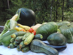 Must remember to go to the garden every day; this is what happens with one day skipped. Corn, cucumber, zucchini, watermelon, yellow squash, tomato, buttercup, butternut, and eggplant. 34 pounds.
The zucchini are playing out; most of these we wouldn’t have bothered picking a week ago. The tomato, corn, and watermelon are new this picking.